The Dawn of Spatial Intelligence: How Google’s New XR Geospatial API is Redefining Reality
The landscape of personal computing is undergoing a seismic shift. For decades, our interaction with digital information has been tethered to the constraints of the 2D screen—a glowing rectangle that demands our undivided attention, pulling our eyes away from the physical environment. However, at this year’s Google I/O, the tech giant unveiled a suite of tools that signals the end of the "heads-down" era. By introducing the Geospatial API to ARCore for Jetpack XR, Google is effectively giving Android XR devices the ability to "see" and understand the world with sub-meter accuracy.
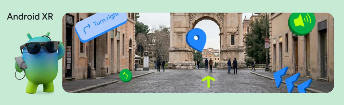
This leap forward isn’t just about overlaying digital stickers onto a camera feed; it is about anchoring the internet to the fabric of physical reality. To demonstrate the potential of this technology, Google’s engineering teams constructed the XR Geospatial Tour, a proof-of-concept application that transforms a simple pair of XR glasses into an intuitive, hyper-aware local guide.
The Core Innovation: Bridging GPS and VPS
At the heart of this transformation is the integration of the Visual Positioning System (VPS) into the Android XR ecosystem. While traditional GPS is the industry standard for location, it often falters in "urban canyons"—dense city streets where skyscrapers obstruct satellite signals—and lacks the vertical and orientation precision required for true spatial computing.
The Geospatial API solves this by leveraging advanced computer vision. By comparing what the device’s camera sees against Google’s vast, high-fidelity database of 3D map data, the API can triangulate a user’s position with unprecedented reliability. It provides a GeospatialPose, which includes not just latitude and longitude, but precise heading and orientation. This allows developers to place digital waypoints that remain locked to a specific physical coordinate, whether it’s a historic statue or a hidden cafe entrance, regardless of how the user moves or turns their head.
Chronology of Development: From Concept to Reality
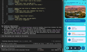
The journey to the XR Geospatial Tour was a multi-staged integration project that highlights how modern AI and spatial frameworks can be woven together:
- Phase 1: Establishing the Spatial Anchor. The process begins with the ARCore session. Developers must first initialize the session and continuously poll for the
GeospatialPose. A critical aspect of this phase is the "readiness check." Because spatial accuracy is paramount, the application monitorshorizontalAccuracyandorientationYawAccuracy. If the device is indoors or in a GPS-denied environment, the system intelligently prompts the user to move toward a more public, feature-rich outdoor space. - Phase 2: Intelligent Itinerary Generation. Once a precise location is established, the app calls upon the Gemini API using Firebase AI Logic. By passing current coordinates to the LLM, the system requests a structured JSON itinerary. To ensure this data is grounded in reality, Google integrated Google Maps Grounding. This prevents the AI from "hallucinating" landmarks that do not exist, ensuring that every tour stop is geographically verified.
- Phase 3: The Conversational Layer. Moving beyond text, the team utilized Gemini 2.5 Flash TTS. By configuring the model to return
ResponseModality.AUDIO, the system bypasses the need for traditional third-party text-to-speech engines, generating natural, context-aware audio directly from the generative model. - Phase 4: Spatial UI Integration. Finally, the Jetpack XR SDK acts as the rendering engine. Using Compose for XR, developers build "InfoSpheres"—3D objects that float in the user’s field of vision. These elements are rendered using
SpatialBoxandSceneCoreEntity, allowing for a seamless blend of traditional 2D menus and interactive 3D content.
Supporting Data: The Convergence of APIs
The technical architecture of the XR Geospatial Tour serves as a blueprint for future spatial applications. The following table illustrates the roles played by each component in the ecosystem:
| API/Component | Primary Function | Role in XR Tour |
|---|---|---|
| ARCore Geospatial API | Visual Positioning (VPS) | Provides sub-meter location accuracy. |
| Gemini API (Firebase) | Large Language Modeling | Generates tour content and context. |
| Google Maps Grounding | Data Verification | Ensures AI-generated locations are real. |
| Gemini 2.5 Flash TTS | Audio Synthesis | Delivers the "voice" of the tour guide. |
| Jetpack XR SDK | Spatial Rendering | Manages 3D UI and interactions. |
This convergence of technologies allows developers to build "world-scale" experiences without needing to build their own mapping databases or complex computer vision backends from scratch.
Official Perspectives: The Developer Catalyst Program
Google’s strategy is clearly focused on lowering the barrier to entry for spatial developers. During the announcement, the team emphasized that the "barrier to entry for world-scale spatial experiences is lower than ever."
To facilitate this, Google has launched the Android XR Developer Catalyst Program. This initiative is a direct response to the primary criticism of XR development: the lack of accessible hardware. By providing developers with access to the XREAL Project Aura devkits and other display hardware, Google is creating an ecosystem where developers can iterate on real-world glass, not just emulators.
"Our goal is to ensure that when a developer writes code for Android XR, it feels as intuitive as writing for a mobile device," stated a spokesperson during the I/O briefing. "By combining the familiarity of Jetpack Compose with the power of spatial anchors, we are moving the industry toward a future where the internet is not something you look at, but something you inhabit."
Implications: A New Paradigm for Interaction
The shift toward spatial computing via the Geospatial API has profound implications for several industries:
1. The Future of Tourism and Navigation
The days of staring at a blue dot on a 2D map are numbered. In the near future, tourists will wear lightweight glasses that highlight paths, annotate landmarks, and provide real-time audio commentary. Because the system is anchored to physical objects, these annotations will remain stable, providing a sense of immersion that 2D maps simply cannot replicate.
2. Context-Aware Retail and Commerce
Retailers stand to gain significant ground by using these APIs to create "spatial storefronts." Imagine walking past a store and seeing a digital price tag, a personalized review score, or a virtual promotion floating exactly where the item is located in the window. This creates a frictionless bridge between physical browsing and digital conversion.
3. The Democratization of Spatial Development
Historically, building a spatial app required specialized knowledge in proprietary engines and complex mapping algorithms. By integrating these capabilities into standard Android development workflows (like Jetpack Compose), Google is essentially opening the floodgates. Any Android developer proficient in Kotlin can now begin building world-scale AR experiences, potentially leading to an explosion of utility-focused spatial apps.
4. Ethical and Privacy Considerations
While the technology is transformative, it brings new responsibilities. The use of high-fidelity camera data to perform VPS raises questions about how user data is processed and stored. Google has maintained that the Geospatial API is designed with privacy-first principles, but as these devices become more common, the societal norms around "spatial recording" will need to evolve.
Conclusion
The XR Geospatial Tour is more than just a clever demo; it is a declaration of intent. Google is betting that the next major platform for information consumption will not be the phone in our pockets, but the digital layer draped over the physical world.
By combining the precision of the Geospatial API with the creative power of Gemini and the developer-friendly ecosystem of Jetpack XR, the path to the "Metaverse"—or whatever the next iteration of the web is called—is becoming clearer. It will be an environment defined by persistent, accurate, and intelligent digital overlays. For developers, the time to start building is now. The physical world is the new canvas, and the tools to paint upon it have finally arrived.