The Invisible Mirror: Understanding How Raindrops Act as Antennas and Shape Modern Radar Technology
In the intricate dance between electromagnetic (EM) waves and the physical environment, almost every object acts as an antenna. From the salt-water composition of the human body to the microscopic moisture suspended in the atmosphere, matter is rarely transparent to the full spectrum of radio frequencies. While this phenomenon is often viewed as a technological hurdle—a source of signal attenuation or noise—it is also the fundamental principle that enables modern meteorology.
A recent technical deep-dive by researcher Marshall Bruner has shed new light on the physics of how raindrops interact with EM radiation, specifically within the Rayleigh regime. By demystifying the dipole nature of precipitation, this research provides a clearer roadmap for engineers and scientists looking to optimize radar systems for everything from aviation safety to extreme weather forecasting.
Main Facts: The Raindrop as a Dipole
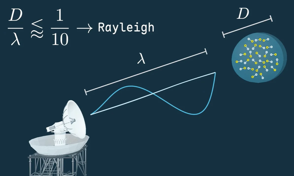
At its core, the interaction between a radar pulse and a raindrop is a study in polarization. When an electromagnetic wave encounters a water droplet, the wave’s oscillating electric field exerts a force on the charges within the water. Because water is a polar molecule, the droplet’s internal charge distribution is momentarily disrupted.
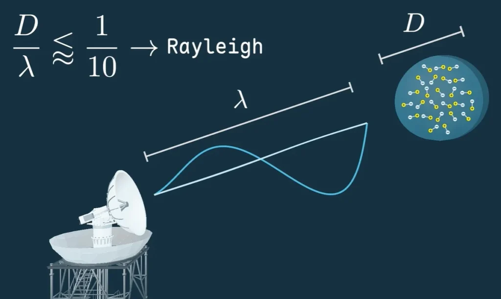
This disruption forces the raindrop to act as a tiny dipole antenna. The droplet begins to oscillate in sympathy with the incoming frequency of the radar signal. This process is not merely passive; it results in the re-radiation of EM energy. While some of this energy continues forward, a significant portion is scattered, and a fraction—known as backscatter—is reflected directly back toward the radar’s receiver.
The strength of this backscattered signal is governed by several variables, primarily the volume of the droplet and its dielectric permittivity. Because water has a significantly higher permittivity than the surrounding air, even small droplets can create a detectable "echo." This is the foundation of weather radar: by measuring the intensity and timing of these returning echoes, meteorologists can map the density, size, and type of precipitation within a cloud structure with remarkable precision.
Chronology of Scattering Theory
The scientific journey to understand these interactions spans over a century, beginning with the foundational work of Lord Rayleigh in the late 19th century.
- 1871: Lord Rayleigh publishes his initial research on the scattering of light by small particles, establishing what would later be known as "Rayleigh scattering." His work explained why the sky appears blue: shorter wavelengths (blue) are scattered more efficiently by atmospheric particles than longer wavelengths (red).
- Early 20th Century: As radio technology emerged, scientists began applying Rayleigh’s theories to longer wavelengths. It was discovered that if the particle size is much smaller than the wavelength of the EM radiation, the scattering intensity follows a predictable mathematical relationship proportional to the sixth power of the particle’s diameter.
- Post-WWII: The development of robust radar systems for military and commercial aviation necessitated a deeper understanding of "clutter." Engineers realized that rain wasn’t just a nuisance; it was a data source.
- Modern Era (2020s): The integration of computational power and open-source data analysis has allowed researchers like Marshall Bruner to create visual simulations. These tools move beyond static equations, allowing for the real-time modeling of how radar signals interact with varying drop size distributions (DSD) in complex atmospheric conditions.
Supporting Data: The Physics of the Rayleigh Regime
To understand the efficacy of radar, one must look at the math behind the droplets. Bruner’s analysis focuses on the Rayleigh regime, where the diameter of the particle ($D$) is significantly smaller than the wavelength of the radar ($lambda$).
The Mathematical Framework
The backscattering cross-section ($sigma$) is the critical metric in radar meteorology. In the Rayleigh regime, it is defined as:
$$sigma = fracKlambda^4$$
Where:
- $|K|^2$ is the dielectric factor (related to the complex refractive index of water).
- $D$ is the raindrop diameter.
- $lambda$ is the radar wavelength.
The critical takeaway here is the $D^6$ relationship. Because the backscatter signal grows with the sixth power of the diameter, a doubling of the raindrop size results in a 64-fold increase in the reflected signal strength. This extreme sensitivity explains why radar can easily distinguish between light drizzle and heavy, large-drop thunderstorms, but why it might struggle to differentiate between different types of light, small-particulate precipitation like mist or light snow without advanced dual-polarization techniques.
Computational Modeling
Bruner’s work incorporates Python-based notebooks that allow users to input varying drop size distributions. By adjusting variables—such as the concentration of water per cubic meter—the model demonstrates how the cumulative backscatter signal shifts. This computational approach allows for the creation of "synthetic radars," which can be used to calibrate real-world sensors before they are deployed in harsh environments.
Official Responses and Engineering Perspectives
Industry experts and atmospheric scientists have increasingly leaned into these computational models to refine "clutter rejection" algorithms. In aviation, the goal is to filter out the noise of light rain so that pilots can see the dangerous, high-density cores of storm cells.
"The fundamental challenge," notes one radar systems engineer, "is that the raindrop doesn’t know the difference between a weather radar pulse and a telecommunications signal. It responds to the physics of the wave, not the intent of the operator."
The consensus among radar manufacturers is that the future of weather tracking lies in "Polarimetric Radar." By sending pulses with both horizontal and vertical polarization, modern systems can observe the shape of the falling drops. Raindrops are often flattened by air resistance as they fall, whereas snowflakes or hail may be spherical or irregular. By analyzing how the "dipole antenna" response differs between horizontal and vertical axes, modern radar can differentiate between rain, sleet, and snow with an accuracy that was impossible just two decades ago.
Implications: From Weather Forecasting to Signal Integrity
The implications of understanding the raindrop-as-antenna are twofold: one for the observer, and one for the communicator.
For Meteorologists
Enhanced understanding of the Rayleigh regime allows for more precise "quantitative precipitation estimation" (QPE). By accurately modeling the backscatter from different precipitation types, meteorologists can provide more accurate flood warnings and localized weather updates. This is particularly vital in a changing climate where extreme precipitation events are becoming more frequent and localized.
For Telecommunications
For those operating in the microwave or millimeter-wave bands (such as 5G or satellite communications), the "curse" of the raindrop is significant. As signals travel from base stations to devices, the atmospheric moisture acts as a parasitic antenna, absorbing and scattering the signal. This is why high-frequency internet services often experience drops in performance during heavy rain.
Engineers are now using models similar to those presented by Bruner to design "adaptive modulation" systems. When a network senses increased backscatter or signal attenuation caused by rain, the system can automatically shift to a more robust, lower-frequency, or error-corrected signal mode to maintain connectivity.
The Educational Frontier
Bruner’s initiative highlights a broader shift toward "open science." By providing the Python notebooks alongside the video primer, he lowers the barrier to entry for students and amateur radio enthusiasts. This democratization of knowledge ensures that the next generation of RF engineers and meteorologists understands the physical reality behind the screen, rather than treating the radar as a "black box."
Conclusion
The raindrop is, in every sense, a tiny, ephemeral antenna, constantly re-radiating the energy that hits it. Whether we are trying to clear that signal to transmit a phone call or amplify that signal to track a hurricane, the physics remains the same. By bridging the gap between abstract Rayleigh scattering theory and modern computational tools, the scientific community is moving toward a more nuanced mastery of our electromagnetic environment. As we continue to push into higher frequency bands for communication and rely more heavily on hyper-local weather data, the humble raindrop will remain a primary focus of engineering, demanding our respect and our continued analytical scrutiny.